Město Podivín
Město Podivín

The royal town of Podivín

Podivín - historical photo

Podivín is one of the oldest towns in Southern Moravia and has had a strategic purpose since early Middle Ages. It lays on an elevated plateu, and at that time was surrounded by a river and a swamp. In 1067, a castle stood here and its purpose was to protect the Dyje river crossing. Direct references are documented in written sources of the Chronicle of the Czechs by Cosmas.

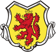
The exact location of the castle has never been identified. Podivín received a town status in 1222. Podivín was entitled to its mintage rights and was the center of a decapitation court. Podivin’s coat of arms has displayed two-tailed lion with a golden crown since 1297. Podivín was granted many rights leading to a designation „a royal town“.

John´s castle, photo by L. Hrdlička

John´s castle, photo by L. Hrdlička


Densely populated Podivín became a symbol of religious tolerance. Christian and Jewish communities had lived here together and were joined by Anabaptist-Haban community in the 16th century. Fishing guild acquired the most important significance. The Duke of Lichtenstein constituted „The Book of Fishing“ in 1717 which confirms the articles of a fishing guild. The original book has been preserved until present and is owned by Subsidiary Fishing Club of Podivín.


Local elementary school , built by the Duke John of Lichtenstein, certainly belongs to the most important real and cultural sights. Other sights are represented by Jewish cemetery and its ceremonial entrance chapel and Neo-Gothic church of St. Peter and Paul with its adjacent parish office and historical Town Hall which was reconstructed in 2019. Other significant historical sights earning attention are: a Chapel dedicated to Cyril and Methodius, a Cemetery Gate, St. Anna’s Chapel, Immaculaty Statue or a Statue of St. John of Nepomuk.

John’s castle is the most frequently visited protected cultural site which belongs to Podivín’s real estate territory. This pseudo-Gothic imitation of a castle ruin is hidden in the middle of floodplain forest by headland of the Old Dyje river.


Podivín and its surroundings are located in Dolnomoravský úval (South Moravian ravine). Dyje-Morava meadow acts as an axis of the area and with its elevation of 171,3 meters is the lowest part of Dolnomoravský úval. The Dyje river has formed the entire landscape behind Podivín for centuries by undermining mainly during spring flood seasons. The vast and irreversible changes of the landscape happened after regulations of the Dyje river and a construction of  Nové Mlýny Dam in 1972. Despite these changes, yet many protected and endangered species of plants, animals and birds still appear here.

The population of Podivín is 3001 residents (population census January 1, 2018). Considering its location, Podivín represents an ideal entrance to the Lednice-Valtice Area.

Podivín – Church of St. Peter and Paul with a reconstructed Town Hall, photo by L. HrdličkaPodivín – Church of St. Peter and Paul with a reconstructed Town Hall, photo by L. Hrdlička

Geoportál města

Geoinformační sytém města Podivína

mapy

katastr nemovitostí

územní plán

inženýrské sítě

posporty

Aplikace v Obraze

V obraze

Google playApp Store

Svátky a výročí

Dnes je 19.3.2024

Svátek má Josef

Státní svátky a významné dny na dnešek:

  • Mezinárodní den invalidů

Kalendář akcí

Po Út St Čt So Ne
26 27 28 29 1 2
1
3
4 5 6 7 8 9
1
10
11 12 13 14
1
15 16 17
18 19
1
20 21 22 23
1
24
25 26 27 28 29 30 31
1